North Jerusalem
Giv’at Ze’ev to Beit Hanina
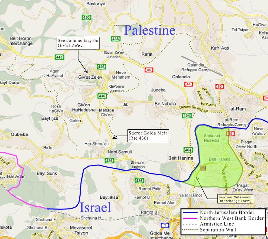
The Citizens Proposal puts a particular focus on the Israeli communities in the Giv’on Bloc because uniquely as settlements they are situated between Tel Aviv, Jerusalem and Ramallah, but they are sufficiently far enough from Jerusalem and Tel Aviv to be considered contiguous to Ramallah. The Giv’on Bloc and the separation barriers erected around it divide Palestinian communities southwest of Ramallah and obstruct the development of a central city, Ramallah. With most of this area apportioned to Palestine and the removal of separation barriers, there will be improved community interaction, and people will get on with daily living. However, without assurances of access to Israel, we cannot see that peace can be substantial. To relocate 30,000 people is hardly reasonable. Our borders seek to be reasonable and fair.
The Citizens Proposal asks that Palestine and Israel negotiate the terms of a 99-year lease for Giv’at Ze’ev, Mahane Giv’on and Har Shmu’el, including road access along Rte 436 (Sderot Golda Meir), after which time these settlements will be absorbed into Palestine. As a concession, Israel will abandon Giv’on HaHadasha, because the new settlement is not well thought out and impinges on the houses in Bayt Ijza. It is hoped that this sort of agreement—a concession in return for leases of a fixed term, might be a precedent for discussing other settlements, each in a unique way, and thus provide a future for the Jews in those settlements.
The settlements of Agan HaAyalot and Beit Horon (which do not currently front on Rte 436) might ask as well for negotiated leases of shorter time periods in return for concessions to Palestine, whereby they might continue to have a temporary settlement presence even while they begin relocation.
We propose that Nebi Shmu’el (Nabi Samuil) become an international religious site, managed by either party according to the outcome of negotiations. Bayt Iksa is included within Israel, with road access to Jerusalem via Rte 436.
Rte 436 north of the Shmu’el Junction and Rte 404 from Beit Hanina (west) would become Palestinian roads to serve the needs of the growing Ramallah metropolitan area. (NOTE: With the inauguration of the Benzion Netanyahu Interchange linking Rte 20 with Rte 404, the proposed border was adjusted on May 12, 2013 to keep that interchange within Israel. To compensate, the line north of Rte 20 was moved slightly east giving Palestine additional territory up to the western edge of Shikunei Nuseiba; this is in keeping with the Citizens Proposal's aim of limiting the adjustments from the Green Line to 1.9 percent.)
The western end of this segment of border meets the armistice line north of Mevaseret Zion. The route of proposed border will allow the high speed train between Tel Aviv and Jerusalem currently under construction to run entirely within the territory of Israel.
On its eastern side, the proposed northern border of Jerusalem extends no further north than the northern limits of Beit Hanina, just south of the al-Ram Refugee Camp. The areas north of this line that are currently part of the Jerusalem municipality are allocated to Palestine: the Jerusalem Airport, the ‘Atarot Industrial Zone and the Palestinian village of Kafr ‘Aqab. In our view, these areas properly belong to the municipality of Ramallah.
Beit Hanina (the area shaded green) could optionally go to Palestine. If so, then Rte 20 and the interchange with Rte 404 would become a Palestinian route connecting Beit Hanina with Ramallah. The border with Israel would then run along the southern edge of the green area and then turn north following Rte 60 but just to the west of it, keeping Rte 60 an Israeli road for access to Pisgat Ze'ev and Neve Ya'akov. Perhaps the residents of Beit Hanina could be offered a referendum on their future status.
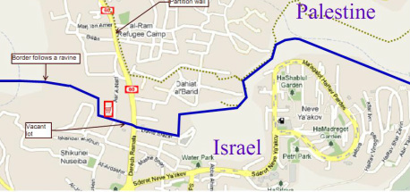
Beit Hanina (detail)We drew the proposed border to minimize disruption to neighborhoods north and north-west of Beit Hanina.
|
|
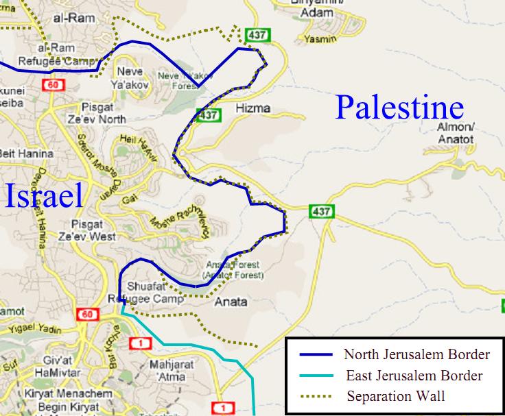
Beit Hanina to ShuafatWe call the feature on the northeast corner
above Pisgat Ze’ev and east of Neve Ya’akov “God’s Thumb”; it signifies
what we believe is the divine inspiration behind this proposed border.
It expresses poignantly God’s attitude: He is fed up with the lack of
peace among His children, as any parent would be. God wants action;
therefore, He inspired a “line of demarcation” as a reference point for
humanity on earth and in heaven, a starting point as they lobby for
their Israeli or Palestinian interests. The Citizens Proposal retains
this feature of the line of demarcation—God’s signature, so to speak—as
an endorsement of this border and efforts to make it a reality. It is
envisioned that the unoccupied area within the Thumb can become a peace
park in the future.
From the Thumb to Shuafat, the proposed border follows the separation wall except in the Anata forest, where it apportions half of this parkland to the Palestinians of Anata. |
|
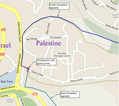
Shuafat Refugee Camp (detail)
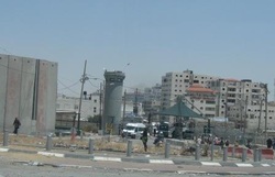
The entrance to the Shuafat Refugee Camp marks the eastern end of the
North Jerusalem section of the proposed border. South of this point
begins the East Jerusalem section (turquoise).
|
|
