Northern West Bank
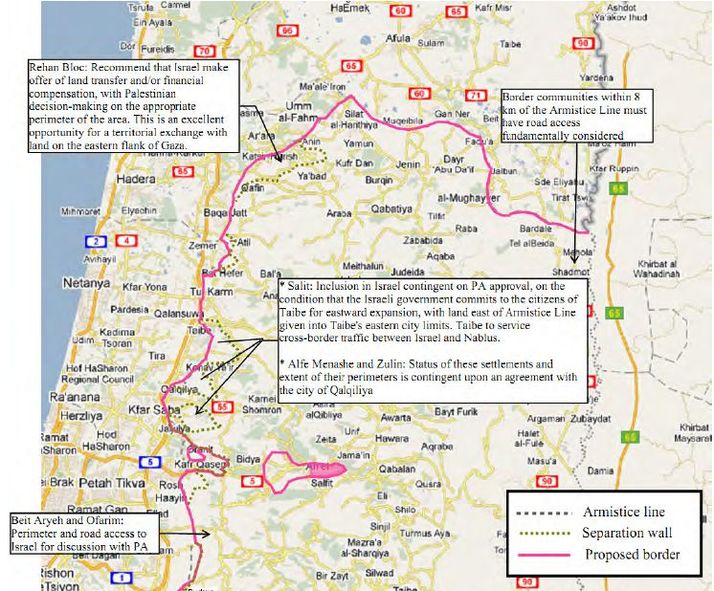
Jordan River to Budrus
The proposed border of the northern West Bank follows the 1967 Line except as otherwise noted (i.e., it follows the separation wall at Oranit and in the segment north of Budrus).
We believe the Jordan River valley should be within Palestine, for reasons of territorial contiguity and to provide natural access from Palestine to Jordan.
Israeli settlements east of the border are within the territory of Palestine. This proposal includes call-outs that outline unique arrangements that could be made for certain settlements, but any such arrangements are contingent on approval by the government of Palestine. Thus, some settlements could be provided with road access to Israel; a few could be brought within Israel by border adjustments; but most would have the sole option to remain as minority communities in Palestine, whence it is hoped that many will continue their daily life in peace and security, living as good neighbors among good neighbors. Generally speaking, border modifications or road access would be considered only for settlements within 8 km of the border. Refer to the discussion of Giv’at Ze’ev for an example of the sort of mutual agreements that might be considered.
The unique enclave of Ariel and adjacent settlements to its west are proposed to become an Autonomous Economic Zone, to be administered jointly by Israel and Palestine and with road access to Israel.
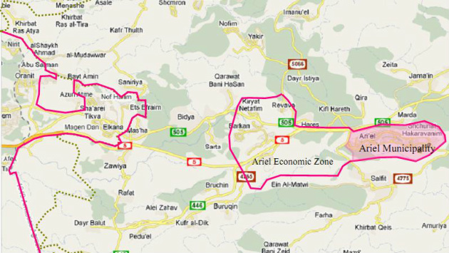
Oranit--Elkana--Ari’el Economic Zone--Ariel
The Citizens Proposal suggests that the
municipality of Ariel (shaded pink) become an autonomous district
administered by its own citizens, under Israeli law. It will be a part
of the Ariel Economic Zone, an autonomous zone jointly administered by
Palestine and Israel with guaranteed right of transit to and from
Israel. Likewise, Palestinians will have unrestricted north–south road
access through the zone from Kifl Hareth and Jama'in to Salfit and
Bouruqin.
The Israeli region of Oranit and Elkana extends eastward, facilitating road access to the Ariel Economic Zone. The proposed border here largely follows the separation wall, except that it does not include within Israel the farms and fields of the Palestinian community of Azun Atme that is situated east of Oranit.
The Israeli region of Oranit and Elkana extends eastward, facilitating road access to the Ariel Economic Zone. The proposed border here largely follows the separation wall, except that it does not include within Israel the farms and fields of the Palestinian community of Azun Atme that is situated east of Oranit.
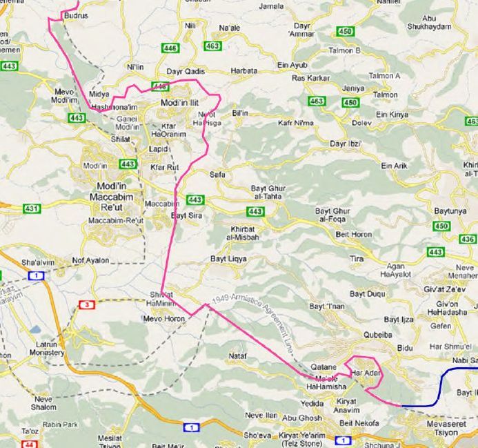
Modi’in Region: Budrus to Mevaseret Tziyon
The settlements of the Modi’in bloc east of
the Armistice Line are placed within Israel because they are part of
the Modi’in metropolitan area. North of Modi’in Ilit the proposed border
extends north-northwest until it intersects the western-most of the two
armistice lines and then follows it north to Budrus. The portion of the
border east of Modi’in Ilit and Kfar Rut is intended to follow the
separation wall, and this particular rendering should not prejudice
changes in the route of the wall resulting from court decisions, as in
the case of Bil’in. South of Maccabim the border follows the eastern
Armistice Line south towards Mevo Horon.
The area where both Armistice Lines protrude into Israel as far as Latrun impinges on the major Israeli highway between Tel Aviv and Jerusalem (as well as the high-speed rail line under construction); hence for purposes of contiguity it is placed in Israeli territory, including Mevo Horon. From Mevo Horon east as far as Har Adar the proposed border follows the western line. The border around Har Adar follows the separation wall and continues east along the armistice line to the junction of the magenta and blue lines. This marks the end of the Northern West Bank segment of the border and the start of the North Jerusalem segment.
The area where both Armistice Lines protrude into Israel as far as Latrun impinges on the major Israeli highway between Tel Aviv and Jerusalem (as well as the high-speed rail line under construction); hence for purposes of contiguity it is placed in Israeli territory, including Mevo Horon. From Mevo Horon east as far as Har Adar the proposed border follows the western line. The border around Har Adar follows the separation wall and continues east along the armistice line to the junction of the magenta and blue lines. This marks the end of the Northern West Bank segment of the border and the start of the North Jerusalem segment.
