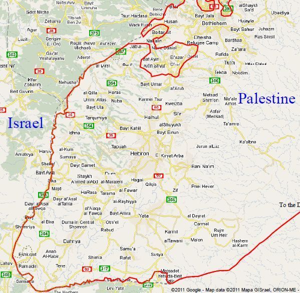
Southern West Bank
The section of
border that began at South Jerusalem continues through the Southern West
Bank to the Dead Sea. Southwest of Gilo the border follows the
Armistice Line until the Etzion Bloc, which is depicted in the detail
map below. From where the separation wall meets the Armistice Line south
of Rte 367 and above al-Dayr, the border follows the separation wall
south all the way to Metsadot Yehuda; then it continues along the
Armistice Line to the Dead Sea. The only exception is the settlement of
Eshkolot, which is not included in Israel.
Where, due to meanderings of the separation wall, pockets of people find themselves east of the Armistice Line but west of the border, they may negotiate for a referendum to be held—contingent upon the two states agreeing to terms and perimeters—to determine for themselves whether their community will be in Israel or Palestine.
Aside from the Etzion Bloc and those along the border in the far south (Sansana, Metzadot Yehuda), this proposal places all the settlements in the southern West Bank within Palestine. Those settlers and communities who are determined to remain may find their future as a Jewish minority within Palestine, and it is our hope that they will find welcome, safety, and the opportunity to build lasting relationships with their Palestinian neighbors.
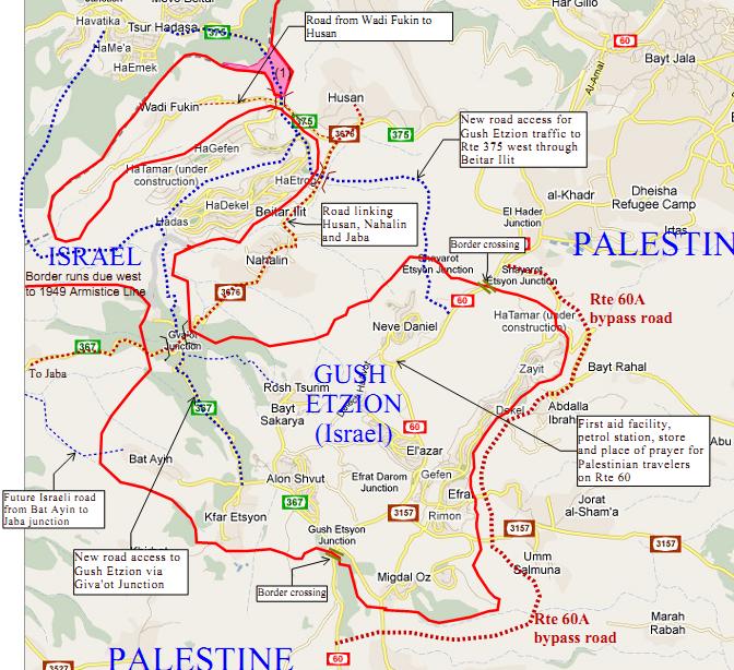
Etzion Bloc (Gush Etzion)
Gush Etzion has a history of Jewish settlement dating
back to the 1920s, and is an area in the West Bank with a Jewish
majority. Our proposal for a Gush Etzion enclave is indicative of the
existent reality that is there. It does not purport that those who live
there are justified, but it does purport that those who live there
believe they are justified. It is neither here nor there to argue which
is true. But it is an imperative to accept that those who live in the
Etzion Bloc must be cared for.
However, the Etzion Bloc impinges on Route 60, the central artery for the southern West Bank connecting Bethlehem and Hebron. The requirement for a contiguous Palestinian state would render an Israeli enclave here untenable unless extensive new roading is constructed. In particular, a new Rte 60A bypass road will be needed to enable Palestinian traffic between Bethlehem and Hebron to flow freely entirely within Palestine. Until that is built, Palestinians and Israelis must have reciprocal rights to travel Rte 60 through Gush Etzion and to and from Jerusalem. We also believe it is important to provide services, especially emergency services, for Palestinian travelers within Israeli territory. Hence we propose a first aid facility, petrol station and convenience store along Rte 60 near Neve Daniel. It can also include a place for prayers.
At the same time, new roads will be needed to connect Gush Etzion with Israel. We propose two roads, one over a strip of land at Giva'ot Junction, and the other to Beitar Ilit and connecting with Rte 375 west to Tsur Hadasa. At the same time, there should be road access for Palestinians traveling between the local villages of Husan, Nahalin and Jaba.
What’s fair is fair, and in providing consideration for the settlements in the Etzion Bloc, we would also offer consideration to Wadi Fukin, an Arab agricultural community lying between the Armistice Line and Beitar Ilit. We would provide it with broad land access to the north at the strip of land labeled (1). However, this strip of land is also the path of Rte 375, the main access in and out of Beitar Ilit. Therefore, while it will remain in Israeli hands for a time, it will revert to Palestine once new roads are built out of Beitar Ilit to the south that connect with the new Ezion Bloc access road through Giva’ot Junction. In any case, it will revert to Palestine on the fourth anniversary of the signing of the agreement that establishes this border.
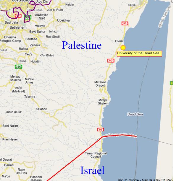
Dead Sea
We propose, to promote good will and international peace, that a Jewish
university be placed in Palestine on the shores of the Dead Sea,
preferably south of Ovnat, within easy driving access to Jerusalem. The
university will have faculties in economics and business, religious
study, and the advancement of agriculture in arid areas.
|
|
